
Map Info
Sprint
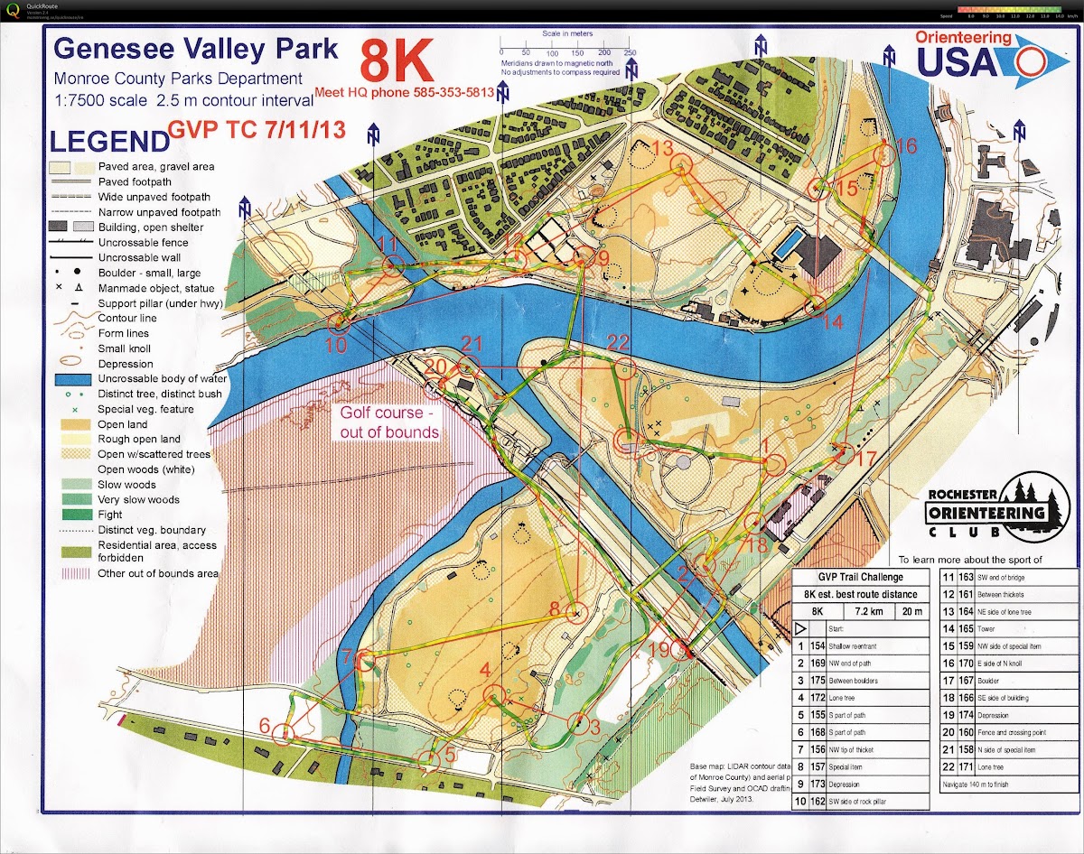
Genesee Valley Park
Genesee Valley Park is a Frederick Law Olmsted designed park that is dominated by three intersecting waterways, Red Creek, the Genesee River and the Erie Canal.
Scale: 1:5000
Contours: 2.5m
Standard: ISSOM 2007
Mapper: Mark Dominie 2013
Genesee Valley Park Trail Challenge (2013 July) - RouteGadget | jpg
The area of Genesee Valley Park that we are using is quite open and relatively flat (the largest hills on the courses will include some of the bridges), so the running will be very fast. As the courses include a fair amount of interaction with roads and paved paths, spiked shoes are NOT recommended.
Please note that a non-ISSOM symbol is used on the maps to represent individual trees: a white circle with green outline, with the size of the circle varying with the size of the canopy provided. The utilization of mapping of single trees vs. scattered trees (with the usual symbol) is quite consistent, but can be tricky to differentiate at high speed.
The 390 highway is shown as transparent gray in the areas where you can cross under and the pylons are shown. The section where there is no access is marked as out of bounds, you have to use the bridges to cross over.
Long and Middle
Letchworth State Park East Side
Letchworth State Park, renowned as the "Grand Canyon of the East," is one of the most scenically magnificent areas in the eastern U.S. The Genesee River roars through the gorge over three major waterfalls between cliffs, as high as 600ft (180m) in some places, surrounded by lush forests. A new ISOM map of the park will be used.
Scale: 1:7500, 1:10000 and 1:15000
Contours: 5m
Standard: ISOM 2000
Mapper: Mark Dominie 2013
Letchworth State Park East (2004) - sections shown on Bulletin, Flyer and header
Previous map available for purchase through online registration
The park also has a mix of rolling hills with a moderate trail network. Major trails have blazes and are very apparent. Indistinct trails are not blazed and tend to disappear in places. Deer trails are numerous and are not mapped but do offer pathways through the thicker vegetation.
Vegetation varies from open pine forest to forest with undergrowth to very uncomfortable briars. The ample rain early in the summer contributed to the growth of vegetation in general but especially to wild rose briars. These are unlikely to decrease by meet time. Rough open is quite tall in places, often over waist high. These areas are marked with green slash. There are plenty of seepages that vary with the amount of rainfall, most can be identified by the fern growth, not all are mapped. Fortunately, there are plenty of areas of open woods that are a mix of evergreen and deciduous trees. Distinct evergreen trees are mapped with a green circle but only where they are lone and big. Green X's indicate lone deciduous trees. In areas with numerous large trees only the most obvious ones are mapped. There is some POISON IVY, those who are allergic should wear leg and ankle cover.
The long courses encompass all the different terrains you will find at Letchworth, steep open slopes, rolling hills, numerous reentrants, small streams and erosion gulleys and some green vegetation. Some hillsides can be very steep and loose and it is impossible to tell until you start uncontrollably sliding down them.
A special feature on this part of the map is a black circle, which represents metal junk. There may be a piece or more than one.
There are a few trails and couple roads that run through the map. The road running along the NE part of the map is public and is used by hikers and visitors. The buses will also be traveling along this road to transport people between the start, finish and assembly area. Blue and Red runners will run along the road so please be cautious. The dirt road that runs along the SW edge of the map will be closed to traffic other than meet workers.
Several sections of old wire fence still exist along the area which bisects the Middle Course and also in other parts of the park. Extensive efforts have been made to map the sections that are above the knees or flag the areas that are still present at ground level. However, some unmarked/unmapped areas may exist.
Parents especially need to be aware that the cliffs leading down to the gorge are, at certain points, fairly close to the trail running along the top. THESE CLIFFS ARE VERY DANGEROUS! They can be unstable along the edges. We have put yellow caution tape along part of the area nearest the event center indicating areas runners should not cross. Please emphasize to your children and anyone else who is looking to see what is down there that they should not cross the tape or venture out onto the edge.